تنزيل العرض التّقديمي
العرض التّقديمي يتمّ تحميله. الرّجاء الانتظار

1
Department of Geographic Information System and Remote Sensing
Geomorphology Chapter 5 Hydrology Dr. Atef Mashagbah Department of Geographic Information System and Remote Sensing Al-albayt University

2
Hydrology The flow of water across and through near surface environments

4
Precipitation Formed by water vapor in the atmosphere
As air cools its ability to ‘hold’ water decreases and some turns to liquid or ice (snow)
")
5
Biomes and Rainfall القطب الشمالي معتدل

6
Evaporation & Transpiration نتح
Fig. 4.1

7
Transpiration the passage of water through a plant from the roots through pores in their leaves to the atmosphere. Fig. 4.4

8
Plant Transpiration Most water absorption occurs in upper half of root zone

9
Evaporating lake with salts around it margin, eastern Washington

11
Hillslope Hydrology Runoff Processes: overland flow
Water Flow Runoff Processes: overland flow Subsurface stormflow, Return flow Groundwater flow

12
Overland Flow overland flow occurs when the rainfall intensity exceeds the infiltration capacity

13
Overland Flow If rainfall exceeds soil infiltration capacity:
Water fills surface depression (منخفض)then Water spills over downslope as overland flow and go to the stream
then. Water spills over downslope as overland flow and go to the stream.")
14
Macro pore flow, Tennessee Valley, California

15
Saturation Overland Flow
Direct rainfall onto saturated areas. Return flow from saturated soils in topographic lows and along valley bottoms where water table rises to intersect the surface.

16
Overland flow, Tennessee Valley, California

17
Overland flow, Tennessee Valley, California

18
Groundwater & the Vadose Zone

19
Driven by hydraulic gradients
Groundwater Flow Driven by hydraulic gradients Q = K I A K is hydraulic conductivity A is cross sectional area I is hydraulic gradient

20
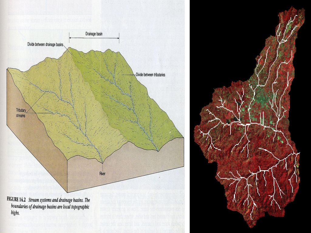
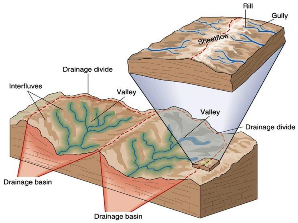
Drainage basin: - Is the geographic area from which a
stream system draws water. حوض المجرى المائي:- هي المنطقة الجغرافيه التي يستمد النهر مياهه منها The volume of water in a stream at any spot related to: - حجم المياه الموجودة عند أي نقطه على طول قـناة المجرى المائي لها علاقة بما يلي:- The size of the area drained مـسـاحـة منـطـقه حوض الصرف The amount of precipitation in the area كمية الاهطال هـناك How readily water infiltrates into the ground (depends on soil moisture, and vegetation) سهولة ارتشاح المياه لداخل الأرض (وتعتمد على رطوبة التربه الغطـــــاء النباتي).
 سهولة ارتشاح المياه لداخل الأرض (وتعتمد على رطوبة التربه الغطـــــاء النباتي).")
23
A tributary Stream:- Is one that flows into another stream.
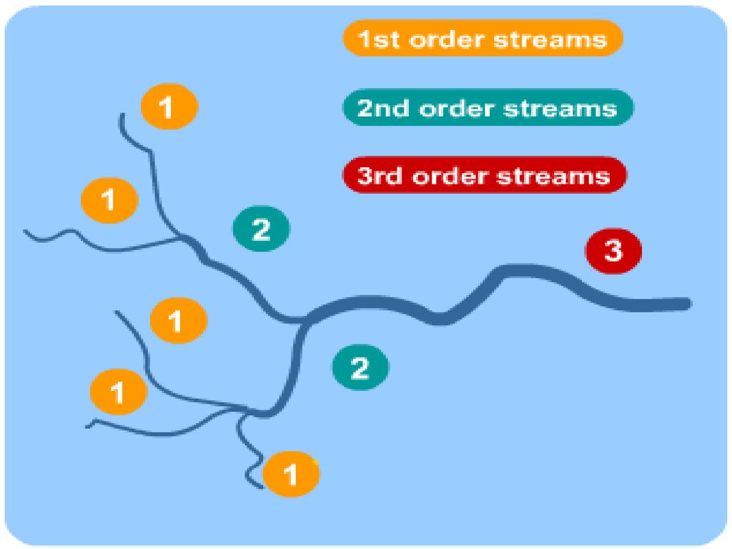
Divide:- Is the boundary between adjacent drainage basins; it is a topographic high knows as divide. الحـد الـفـاصل بين الأحواض المتجاورة من تضاريس عاليـة جـبلـيّ A tributary Stream:- Is one that flows into another stream. النهر التابع(الفرعي):- عندما يصب النهر الصغير في نـهر أكبر منه. First-order stream :- Is one into which no tributary flow نهر احادي النظام نهر بدون روافد Second-order Stream:- Is one that has only first ordered streams as tributaries, and so on. نهر تصب فـيه روافـد أحاديّـة ألـفـروع نهر ثنائي النظام:-
:- عندما يصب النهر الصغير في نـهر أكبر منه. First-order stream :- Is one into which no tributary flow نهر احادي النظام نهر بدون روافد. Second-order Stream:- Is one that has only first ordered streams as tributaries, and so on. نهر تصب فـيه روافـد أحاديّـة ألـفـروع نهر ثنائي النظام:-")
25
Generally the higher the order of the stream, the larger the area drained by the stream and its tributaries. The Mississippi River is the single tenth order stream, drains about 3.2 million square km. عادة كلما زاد عدد الروافد لأي نهر، كلما زادت المساحة التي يتم صرفها بواسطة النهر وفروعه.

26
النمط التركيبي للـصخـور
Drainage Geometry هندسة شبكات نظم الصرف The drainage network consists of a connected net work of streams and tributaries, which collectively form a defined drainage system, that is influenced by the following factors: - يتكون نظام الصرف من شبكة متـصلة من المجاري المائية والتــي تشكل مجتـمعـة نـظاما معينا للصرف ويتحكم في هذا النظام العوامــــل التالية:- Rock composition and its resistance to weathering and erosion. مكونات الصخر التي يتم اختراقها من قبل النهر ومدى مقاومتها لعمليات التجوية والتعرية. 2. Rock structured pattern such as fractures, fault joints…etc. النمط التركيبي للـصخـور

27
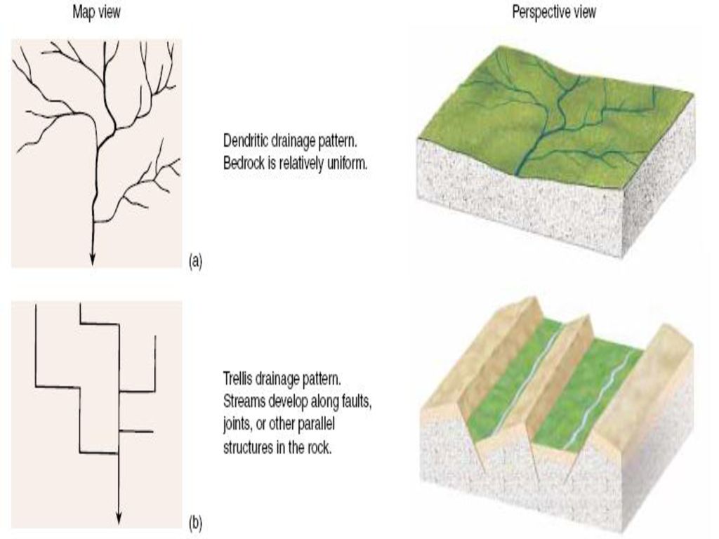
According to this four systems are recognized:-
و بناء على ما سبق فـقد تم التعرف على أربعـة نـظـم للـصرف. I. Dendrite drainage system (branching). This system is characterized by: نـظـام الصرف المتـشـجر ويتصف بما يلي a. Stream channels are irregular قنوات النهر غير منتظمة b. Tributaries join the main channel at a variety of angles الفروع مع الأصل بزوايا مختلفة تتصل c. Characteristic of areas of similar rock composition يسود في المناطق المتجانسة من حيث التركيب الصخري. d. reflect uniform bedrock صخور الاساس متماثله
. This system is characterized by: - نـظـام الصرف المتـشـجر ويتصف بما يلي. a. Stream channels are irregular قنوات النهر غير منتظمة. b. Tributaries join the main channel at a variety of angles الفروع مع الأصل بزوايا مختلفة تتصل. c. Characteristic of areas of similar rock composition. يسود في المناطق المتجانسة من حيث التركيب الصخري. d. reflect uniform bedrock صخور الاساس متماثله.")
30
II. Trellis Drainage System.
This system is characterized by:-نـظـام الصرف (الشعري) ويتصف بما يلي a. Tributaries join the main channel at right angles. تتصل الفروع مع القناة الرئيسية بزوايا قائمة. b. Tributaries are parallel to each other and have the same length. تكون الفروع موازية لبعضها و متساوية الأطوال c. Developed in areas where the topography is dominated by parallel ridges of hard resistance rocks, with soft rocks in between. Streams tend to flow between those ridges. تتكون في المناطق التي تتـمـيز طبـوغـرافـيتها بتـتـابع سلاسل متوازية من الصخور الصلبة يتخللها صخور قليلة الصـلابة، حيث تعـمل عمليات التجوية والتـعـرية على تآكلها وتعريتها بسهولة. و تجري الأنهار ما بين هذه السلاسل في المناطق ذات الصخور اللينة.
 ويتصف بما يلي. a. Tributaries join the main channel at right angles. تتصل الفروع مع القناة الرئيسية بزوايا قائمة. b. Tributaries are parallel to each other and have the same length. تكون الفروع موازية لبعضها و متساوية الأطوال. c. Developed in areas where the topography is dominated by parallel ridges of hard resistance rocks, with soft rocks in between. Streams tend to flow between those ridges. تتكون في المناطق التي تتـمـيز طبـوغـرافـيتها بتـتـابع سلاسل متوازية من الصخور الصلبة يتخللها صخور قليلة الصـلابة، حيث تعـمل عمليات التجوية والتـعـرية على تآكلها وتعريتها بسهولة. و تجري الأنهار ما بين هذه السلاسل في المناطق ذات الصخور اللينة.")
31
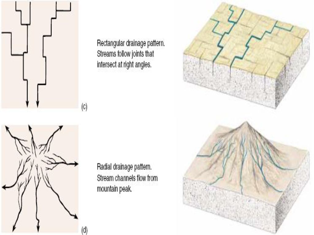
Rectangular Drainage System.
This system is characterized by: - نظـام الصـرف الـمـتعامد:- و يتصف هذا النظام بما يلي:- a. Developed in area that is cross cut by faults and joints. في مناطق المقطعة بالفوالق والتصدعات يتكون مثل هذا النظام b. Tributaries join the main channel at right angles, due to intersecting joints. تتـصل الفروع مع بعضها البعض بشكل عمودي نظرا لـتعـامـد الفوالق والتصدعات مع بعضها البعض هـنـاك c. Stream segments are of relatively equal length between bends. تكون المسافات ما بين الفروع متساوية الأبعاد.

32
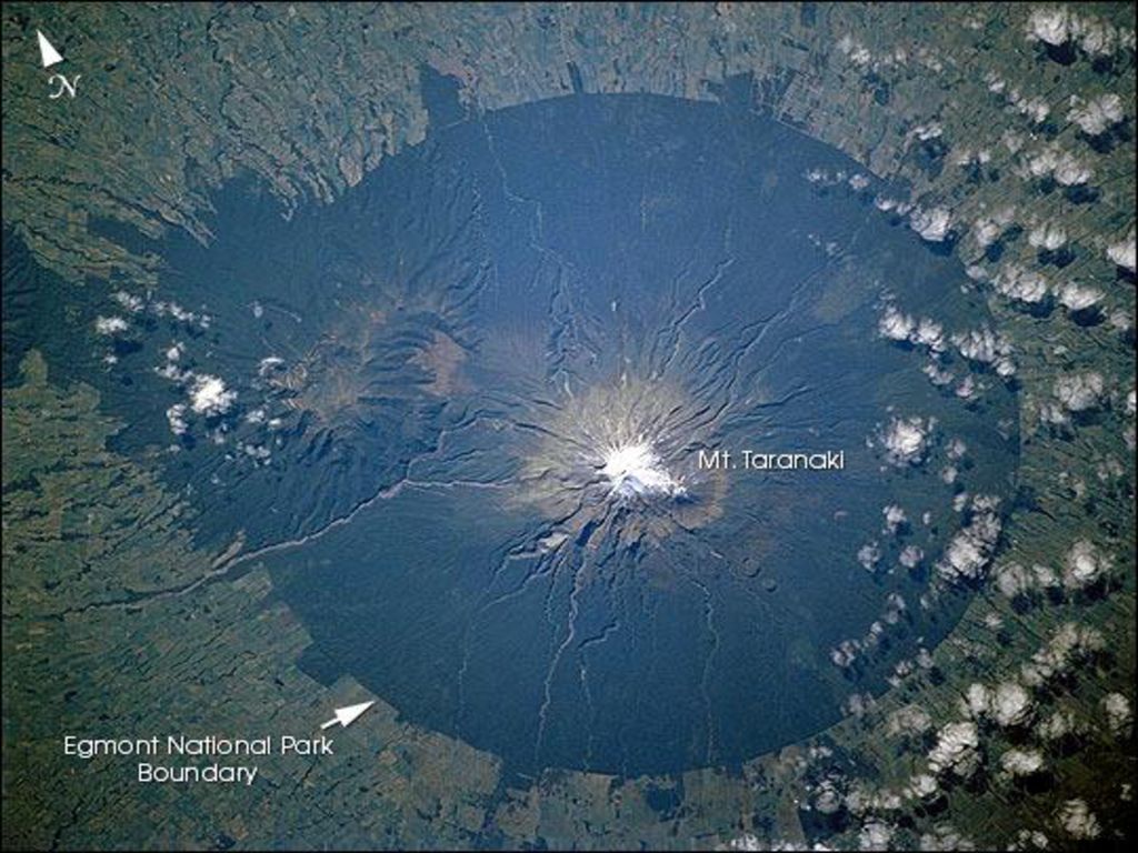
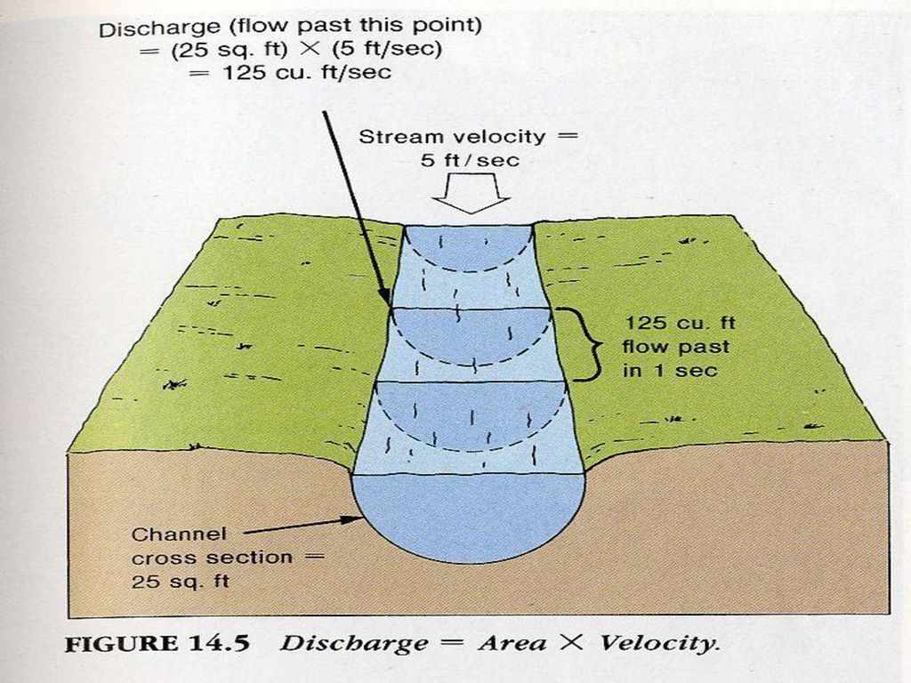
IV. Radial Drainage System نظام الصرف الـشعاعي Developed in areas of conical topographic highs such as volcanoes and domed structure (salt domes), water flows from the top of dome in all directions. يسود هذا النظام في مناطق المخروطيات البركانية والتراكيب القببيـة المرتفعة (قباب ملحية) حيث ينساب الماء من قمة المخروط البركانـي أو القبة الجبلية إلى أسفل المنحدر في جميع الاتجاهات. Discharge:- Is the volume of water, flowing past a given point in a specified period of time m³/sec الدفق :- هي كمية المياه المتدفقة عند نقطة معينة على طول قناة المجرى المائي وخلال فترة زمنية محددة ووحدة قياسها هي م3/ث Discharge = Cross-sectional area of the stream channel (m) X flow velocity (m/s) = Stream width (m) X Stream depth (m) X flow velocity (m3/s)
 حيث ينساب الماء من قمة المخروط البركانـي أو القبة الجبلية إلى أسفل المنحدر في جميع الاتجاهات. Discharge:- Is the volume of water, flowing past a given point in a specified period of time m³/sec. الدفق :- هي كمية المياه المتدفقة عند نقطة معينة على طول قناة المجرى المائي وخلال فترة زمنية محددة ووحدة قياسها هي م3/ث. Discharge = Cross-sectional area of the stream channel (m) X flow velocity (m/s) = Stream width (m) X Stream depth (m) X flow velocity (m3/s)")
35
* Discharge is difficult to measure, because the velocity of the stream is not everywhere the same. Flow is generally slower along the channel and sides where there is friction between water and channel. Faster near the center of the channel and surface of the stream. من الصعب قيـاس التدفق وذلك لأن سرعة الجريان للنهر ليسـت ثابتة على طول مـجـراه، فالتدفق يكون بطيئا عند قعر المجرى المائي و جـوانـبـــــه بسب زيادة الاحتكاك، وسريعا في منتصف القناة تحـت سطح الماء مباشـرة وذلك بسب قلة الاحتكاك أو انعدامه.

36
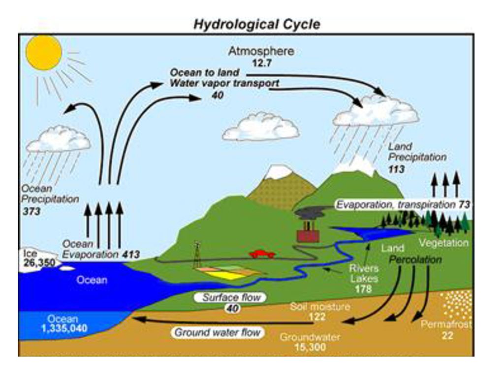
Water balance of drainage basins
Net difference between precipitation and evaporation yields streamflow or groundwater recharge The terms in the figure describe the hydrologic character of the basin. Hydrologic data collection best carried out at the basin scale.

عروض تقديميّة مشابهة
)>")


, ثم يقوم البرنامج بحسابة مساحة المستطيل وطباعته, علماً بأن.>")


>")


